Jan 27, 2012 | Extra-Dimensional
Anomalous objects tracing back to our ancient past are not exclusive to Mars. Strange, unexplained discoveries have been made in recent years throughout our Solar System. Mars by far shows the best potential for having supported an ancient civilization in the distant past. Based on the demonstrated evidence there is a strong probability that advanced life on Mars was a precursor to life here on Earth. However, growing evidence from elsewhere – on neighboring planets such as Mercury, Venus and Saturn, and even our own Moon – points to other intelligent life as also having existed in the distant past. It is quite possible that we on Earth are the final civilization to be living in our Solar System.
In March 1996 it was announced for the first time that artificial structures had been discovered on the Moon. The briefing was given by former NASA scientists, engineers and other researchers, under the title “The Mars Mission”, a grassroots space research and policy group of specialists and citizens. They stated that they were acting independently of NASA, and that their briefing had not been sanctioned by the space agency.
At the briefing in the National Press Club in Washington, D.C. it was stated that, in addition to NASA, the Soviet Union had photographic evidence proving the presence of ancient ruins on the Moon. Video films and photos made by U.S. astronauts during the Apollo program were shown at the briefing. Representatives of the media were extremely surprised as to why the materials had not been revealed to the public earlier. It was indicated that this was due to censorship by NASA and the U.S. government.
These official mission films, analyzed using scientific techniques and computer technologies unavailable to NASA 30 years ago (when the original photographs were taken), now provide compelling evidence for the presence of ancient artificial structures on the Moon.
The former manager of the Data and Photo Control Department at NASA’s Lunar Receiving Laboratory during the manned Apollo Lunar Program, Ken Johnston, has released a number of sensational statements. The specialist said that U.S. astronauts found ancient ruins of artificial origin when they landed on the Moon. He said that the U.S. government had been keeping this information a secret for 40 years.
Astronaut Buzz Aldrin (Apollo 11) in a July 21, 1969 transmission described that several alien spacecraft were located around a nearby crater on the lunar surface. Neil Armstrong, the first man to set foot on the moon (Apollo 11), described an encounter with an alien Moon city or space station and the presence of many spaceships that were far superior in size and technology to ours in his 1969 lunar expedition. According to Armstrong the extraterrestrials have an established base on the Moon and wanted us to leave and stay off the Moon. Have you ever wondered why the Moon landings stopped and why we haven’t tried building a Moon base? After all it seems a better and easier idea than constructing a floating (orbiting) Earth space station.
Well it appears that the final straw for NASA and the U.S. government was the Apollo 17 mission. In December of 1972 Apollo 17 astronauts Eugene Cernan and Harrison Schmitt spent about 75 hours on the lunar surface in the Taurus-Littrow Valley. During their moonwalk they discovered, among many other anomalous artifacts, the severed head of a robot (see photos below). As Cernan put it, even though he was seeing it with his own eyes, he still couldn’t quite bring himself to believe it. He dubbed the entire valley “one mysterious looking place”. Interestingly enough Cernan and Schmitt were the last astronauts to set foot on the Moon. There were no further Moon landings after Apollo 17. After this discovery isn’t it understandable why?
The list of expert testimonials is endless. I describe them in detail in my books. These are not just some geeks reading science fiction books with an over zealous imagination. They are veteran military and Air Force personnel along with astronauts, cosmonauts, scientists, intelligence officials from the CIA (Central Intelligence Agency), NSA (National Security Agency), DIA (Defense Intelligence Agency), and experienced NASA/ESA employees associated with interplanetary missions. And even NASA photo technicians who describe how it is a dedicated job to airbrush anomalous structures and UFOs from Mars and Moon photos before releasing them to the public. More and more highly reputable sources are now coming forward to help expose the truth.
There is hard visual evidence that there are artificial constructions and areas on the Moon’s surface that are being intentionally obscured from view due to image tampering by NASA and the U.S. Navy. Some of these structures have slipped through the censors net and are clearly visible on photographs taken by the Apollo missions and the Clementine satellite. It is only a matter of time now before the public at large finds out that the remnants of an ancient civilization, considerably more advanced than our own, have been discovered on the Moon.
The connection between lost ancient civilizations elsewhere in our Solar System and technology on Earth is this: if many of these structures are artificial by design then the intelligence that built them and which lived on or visited them could very well have been affiliated with Earth’s development in antiquity. Simply witness the uncanny resemblance of Martian structures and monuments to those here on Earth.
The distance between planets within our Solar System is very small compared to distances on the galactic scale. Once it is finally revealed that intelligent life did at one time exist elsewhere in our Solar System, humanoid or otherwise, then we must ask what happened to make these civilizations disappear almost without a trace? What catastrophic event devastated the entire Martian landscape? Why the need to cover-up, lie and purposely mislead the public for decades into believing that there was no life on Mars or within our Solar System? If the culture was advanced it is safe to assume that they had knowledge of or access to space travel. Therefore they could have possibly made a short interplanetary journey to Earth to re-colonize their species here.
As hard as it is to believe, humanoid life on Earth could actually have originated on Mars, or somewhere else in our Solar System. Our ancient history, or earliest beginnings, could be traced to a mass migration from within our own Solar System.
The mysterious “Face” on Mars, glass tube tunnels, forests, vegetation, monoliths, pyramids, scattered ancient artifacts, city complexes, massive towers, and crashed spacecraft are only a few of the hundreds of anomalies we have seen on the surface of Mars that cry out for further investigation. The same applies to unexplained structures on other planets in our Solar System. To dismiss their existence is totally irresponsible on behalf of NASA, the scientific community, and any government agency which has final approval for funding space exploration. Perhaps they are natural phenomena. But we won’t be certain until they are thoroughly and objectively investigated.
Unfortunately we don’t have a roving correspondent traveling throughout our Solar System who is able to report all the action to us. All we can rely on for now are the images (in many cases tampered) released from NASA and ESA, along with statements and testimonies from scientists, astronauts, and researchers associated with interplanetary missions and projects to render an opinion.
With all of the references in Hollywood films and science fiction to “little green men” from Mars the chilling truth may be that we are the real Martians!
Mainstream science would have us believe that Mars and other planets in our Solar System are completely void of life, past and present. However, nothing could be further from the truth. Based on the conclusive evidence I present these planets could very well hold the secrets to humanity’s origins.
Following are just some of the mysteries that are continually explored in my books.
 |
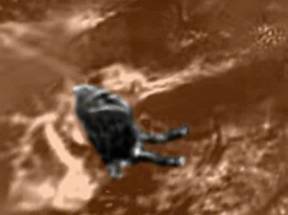
In December of 1972 Apollo 17 astronauts Eugene Cernan and Harrison Schmitt spent about 75 hours on the Moon. During their lunar expedition they took the photo on the left. As incredible as it sounds it appears to be the severed head of a robot. As Cernan put it, even though he was seeing it with his own eyes, he still couldn’t quite bring himself to believe it. After overcoming his initial shock he realized that it couldn’t be a human skull. After all, it was lying in a debris field from an impact crater, which had tossed up all manner of junk and material from just below the valley floor. Something as fragile as a fossilized bone could not possibly survive such an impact. Furthermore, exposure to extreme solar and cosmic radiation would have long since reduced organic material to a fine powder. This object was unmistakably of mechanical origin. Color enhancements showed that the ‘head’ had a distinctive red stripe around the area where the upper lip should be, a feature that clearly appeared to be painted or anodized on the object. Composites of other frames showed that the ‘head’ had two eye-sockets, a forehead, brow ridges, a nose with nostrils, twin cheek bones and the upper half of the jaw. The lower jaw seemed to be missing. Cernan dubbed the area “one mysterious looking place”. Many of the rocks had highly unusual spectral qualities, reflecting light more like crystals or highly polished metallic boxes. The bottom photo is an enlargement of the severed head photographed in Shorty Crater by Cernan and Schmitt. To this day there hasn’t been a satisfactory explanation for this artifact from the scientific community – only personal attacks on the credentials or motives of those who offer it as evidence. Interestingly enough Cernan and Schmitt were the last astronauts to set foot on the Moon. There were no further Moon landings after Apollo 17. After this discovery isn’t it understandable why? |
 |
Our Moon has always been considered desolate and dead. The image on the left is taken directly from the 1994 Navy Clementine military official science data and shown above at standard official resolution demonstrating two massive left and right towering objects in the terrain. Although blur and smudge tampering applications have completely covered up these objects so that no specific details of their true structure can actually be seen, that doesn’t mean that there isn’t plenty here to interpret and learn from. We can tell that these are most likely massive, very tall vertical towering structures that dwarf by far anything else in the terrain around it. The objects wider base footprint tapering to a narrower form as it rises to a more slender top is typical of a very tall skyscraper building here on Earth. However, these on the Moon are much more massive and far taller than anything on Earth, no doubt enabled by the Moon’s much lower gravity. The middle image is another taken from the Clementine satellite. Note that the obscured angular image is still partially visible. Attempts to conceal the towers have not always been successful. As can be seen by the bottom photograph a massive tower is clearly visible on the NASA image enhanced using modern image processing technology. |
 |
This image from the Moon was taken by the Lunar Orbiter. It shows dozens of pointed spires in varying heights scattered across the surface. According to mainstream science our Moon is supposedly a lifeless body of dust, so what are these odd structures? Could these be trees, vegetation, natural geological formations or are they something else? |
 |
The image of this pyramid on the Moon was taken by the Hubble Space Telescope (HST) in December 2008. How can nature create such architectural perfection? What is the purpose of this structure? Is it related to similar pyramid constructions found on Earth and Mars? |
 |
Detailed analysis of photographs released by NASA has revealed evidence of what appear to be ruins and artificial constructions of various types on the Moon. Photographs taken from Apollo spacecraft in lunar orbit show rectangular and square shaped objects in Aristoteles Crater (photo on left). These structures are most definitely not of natural origin. |
 |
The Aristarchus Crater enigma is one of numerous so-called transient lunar phenomena (TLP). It is the brightest spot on the Moon as seen from Earth, which changes color, sometimes producing a red or bluish glow, and appears to emit gas. In 1958 Aristarchus Crater’s strange phenomena were observed by Russian astronomer Nikolai Kozyrev. They were also reported by the crew of Apollo 11. The nature of the crater phenomena has given credence to a theory that there could be some sort of a power device, possibly a fusion reactor, in the crater. On any photo published by NASA except for a Clementine image this object is shown as a bright white smudge with no definition. This structure appears to be supported by 5 or 6 arches. In the foreground is a road that leads to a brightly lit tunnel entrance. |
 |
Another lunar enigma is located at Copernicus Crater. The site appears to resemble an ancient strip mine. As there is no wind or free flowing water on the Moon erosion of the lunar terrain cannot be involved in producing a landscape which resembles a vast mining operation, with debris and rock piles and angled terraces. The topography of the Copernicus Crater, such as ridges and ramps, resembles that of strip mines seen on Earth. |
 |
This lunar image is another view from Copernicus Crater (NASA image PIA00094). Top photo shows a bright object resembling a tower seen highlighted off in the distance. The bottom photo is an enlargement and it shows that this object is hundreds, if not thousands, of feet in height and that it is clearly independently glowing. |
 |
How does NASA explain this? This white structure located in Copernicus Crater seems to have an evident artificial architecture. A horizontal half-circle shape (with a shadow on a part) terminating at the front with a curved plan (on the right) toward the left side. An overhanging ‘head’ is located at the center of the structure. On the left of the object there is a T-like building, with a spherical object above. Lunar location for this anomaly is Eastern Oceanus Procellarum, Mare Insularum. |
 |
There are many more unexplained lunar anomalies. For example, in the upper part of Rima Hadley (photo on left), not far from the place where Apollo 15 landed, a construction surrounded by a tall D-shaped wall was discovered. As is evident in this photo the structure has been deliberately obscured by airbrushing it – yet another case of blatant image tampering. What is hidden behind this smudging? |
 |
This image from the Lunar Orbiter shows a long streak or ribbon rising from the lunar surface. Could this be smoke rising from a campfire on the Moon? A smoke trail from a comet or asteroid would not end/start so abruptly in space. There would be a fading out effect present. This image shows a definite start/stop point where this streak ends or begins in space. Whatever this mysterious object is, it extends several miles into space and doesn’t have an Earthly equivalent. |
 |
Apollo 8 was the first manned spaceflight to leave Earth orbit; the first to be captured by and escape from the gravitational field of another celestial body; and the first voyage to return to planet Earth from another celestial body – Earth’s Moon. This December 1968 transcript (shown on left) references a conversation between Apollo 8 astronauts Commander Frank Borman (CDR), Command Module Pilot James Lovell (CMP), and Lunar Module Pilot William Anders (LMP). They describe bonfires spotted on the lunar surface during Day 4 of their mission. It is doubtful that astronauts, in the midst of a critical mission, would joke about something like this. The fact that the transcript was classified for more than 40 years hints that NASA certainly took this conversation very seriously. |
 |
Apollo 14 was the eighth manned mission in the Apollo program, and the third to land on the Moon. This Apollo 14 transcript (shown on left) describes mining activities observed on the Moon. Command Module Pilot Stuart Roosa (CMP) mentions this during Day 4 of their February 1971 mission. The astronauts believe they see someone mining on the Moon! |
 |
This bizarre lunar object (NASA image AS8-12-2209) was taken by Apollo 8. The bottom photo is a higher resolution version. What could it be – a giant spider, wiring harness, rope or lunar vegetation? |
 |
The two Apollo 8 lunar images on the left reveal a partially obscured structure located within the circular white ring. The lower image is an enlargement (NASA image AS08-13-2350). As you can see, especially in the magnified bottom image, there appear to be multiple height structures rising from the center area of the white ring and this structure evidence is blocking our view of the back white area of the ring. Note that the white ring appears to be of equal depth and reflective quality all the way around. This is typical of other such rings in this and other Apollo 8 images. This configuration would not be the case if this was what we would normally assume it to be which would be an impact crater depression. Normally an impact crater would contain a depression in the center of the impact area and to some degree have a raised rim on the periphery of the depression. Nor does this ring exhibit the shadow characteristics of an impact crater. In other words, we are not looking at an impact crater depression here. There are many of these rings around on the Moon in the Apollo 8 imaging, including more in this particular image, and all of them display a very dark heavily obscured mass like the one shown here, rising in height from the ring’s center area and that height blocks the view of the rear portion of the ring. The tall, dark object rising from the center cannot be a shadow. Shadows always have some transparency depth to them and as such will lighten a bit in a graphics program – but not in this situation. This is more indicative of an image tampering application. But what was someone trying to hide? |
 |
Apollo 10 astronauts took this photo (AS10-32-4822) of a one-mile long object called ‘Castle’, which casts a distinct shadow on the lunar surface. The object seems to consist of several cylindrical units and a large connecting unit. |
 |
This Apollo 10 image AS10-32-4822 shows a square crater on the lunar surface. Since when does Mother Nature carve out square craters? This crater area contains peculiar scored straight lines along the surface. |
 |
Luna 9 was an unmanned space probe of the Soviet Union’s Luna program. On February 3, 1966 Luna 9 became the first spacecraft to achieve a soft landing on any planetary body other than Earth and to transmit photographic data back to Earth from the Moon. Photo on the left is from the Luna 9 probe. It shows what appears to be a large craft or vehicle whose shape resembles that of an ocean going ship on Earth, coming to a point at one end and having an elevated section on top. A cable or tube appears to extend from the rear of the object toward the surface. Contact with Luna 9 was lost on February 6, 1966 just three days after landing. |
 |
Luna 13, also known as Lunik 13, was another Soviet probe in the Luna program. It accomplished a soft lunar landing on December 24, 1966 in the region of Oceanus Procellarum. This intriguing photo was taken before its onboard batteries went dead and transmission stopped on December 28, 1966. The image displays some type of circular disk with a thin axle running through the center and the object is partially buried in the soil. The unknown object was not part of the space probe. Bottom photo is an enlargement. |
 |
This Apollo 16 image is from King Crater on the Moon. Note the unusual structure highlighted inside the red frame. It appears to have a round top or roof. |
 |
This Lunar Orbiter image is from Zeeman Crater on the far side of the Moon. The strange structure shown here has some kind of rectangular opening and is obviously not a natural formation. It appears more like a subterranean entrance. The rectangular opening is 5 miles wide, and one mile high. |
 |
A multi-level lunar structure with openings is highlighted in the top photo on left. It is enlarged in the bottom two photos and is clearly not part of the natural landscape surrounding it, sitting all alone in the middle of a crater-filled surface. |
 |
This lunar anomaly (NASA image LO-5-125-H2A) reveals a tower and several other geometric structures. Is this a natural geological formation or something artificial? |
 |
This image is from the Lunar Orbiter. It shows an unusual structure that resembles a fortress sitting high atop a hill. The many sharp 90-degree shapes, walls, and steps make it highly unlikely that it is a natural geological formation. |
 |
This lunar anomaly shows some type of artificial structures. Could nature form such straight vertical walls with openings (doors or windows)? Some of these buildings also appear to have sloped walls and roofs. Anyone with a shred of common sense would admit that these structures cannot possibly be natural formations. |
   |
The series of five images on left are assorted lunar anomalies observed on the far side of the Moon. The strange object in the top image is some kind of structure with extensions – possibly a crashed spacecraft, or some type of mining device or equipment. Some of the protrusions appear to be attached to or penetrating the nearby lunar surface.
In the image on the left, the area at the bottom of the crater exhibits an organized pattern of perpendicular geometric shapes – an indication of artificial design. Nature is not capable of creating such geometrically precise features. There are clearly visible buildings and roadways. This image is very similar to any aerial photo taken on Earth of an urbanized area.
The photo on the left shows clear evidence of image tampering. The obvious smudging effect in this image is intended to hide a large object – possibly a building or artificial structure. The circular white rings extending from beneath the tall obscured object are likely part of the structure itself. There are several white rings in this image and the smudging is not limited to one single area but continues throughout the photo.
I have nicknamed the structure shown in the bottom two images as the “Roman Coliseum” because of its close resemblance to the famous historical landmark built in Rome, Italy. The bottom image is an enlargement and shows another series of buildings encircling the main structure. What could these separate compartments be – rooms for storage, living quarters, or something else?
As you can see from these images there is something definitely not right on the dark side of the Moon. |
 |
This lunar anomaly is tucked away neatly inside of a crater. The only official NASA description for this Apollo 11 image AS11-41-6156 is “view of area west of Crater 308 from lunar orbit”. The pink circled section is enlarged in the bottom photo and reveals a square structure (perhaps a walled compound) with at least two buildings or objects inside. |
 |
This Apollo 11 lunar image shows a series of buildings situated on either side of a roadway. Note the shadows cast by these buildings indicating (a) that they are definitely vertical structures and, (b) they are all very similar in design. |
 |
Top photo on left is official NASA image from the Moon. Bottom photo is the same photo except that the anomalous objects have been highlighted in color for clarity. Surely these objects cannot be natural rock formations. |
 |
Top photo is another official NASA image from the lunar surface. Bottom photo is the same photo except that the anomalous object has been highlighted in color for clarity. The unusual object looks almost spherical in shape and highly polished. It certainly is not part of the surrounding terrain and looks very much artificial in design. |
 |
The skeptics are hard pressed to call this object a “trick of light” or “just a typical rock”. In this Apollo 16 image you can see a round cylindrical object partially buried with a serrated but symmetrical edge. It resembles gear teeth on a shaft. In order for it to be buried so deeply in the soil it must be quite old. A piece of an Earth probe falling to the lunar surface would only have happened in the last 50 years and therefore clearly visible lying on top of the surface. |
 |
This Apollo 17 image AS17-137-20993HR shows a round object resembling a ring. Once again it is partially buried (probably one-third of the object depth) indicating that it has been there for a long time. It is very unlikely that nature can create perfectly round objects having a hole in the center. |
 |
This image is a screen capture from an Apollo 17 video taken December 12, 1972 from Tsiolkovskiy Crater on the Moon’s far side. It is a 4-minute clip with the astronaut giving a narration but no mention of the strange object located inside the crater is made. You can hear bits of a second conversation in the background, most likely talking on the other secured channel. Halfway through the video the background speaker makes some exclamation of surprise. |
 |
This image shows Reiner Crater on the Moon located just under the four lines of text. The white blurred object to the left of the crater is called Reiner Gamma. On the long tail section extending up from Reiner Gamma is a black square that has been shown for many years as a lunar anomaly on the 1994 Clementine space probe images. |
 |
This Clementine space probe image is from the lunar impact crater Tycho. The mysterious object in this photo looks to be symmetrical with two “nodes” and curved arms extending out from the central body. There appears to be some underlying support just to the left of the right-hand curved “arm”, but the central spherical “node” looks to be located above the ground, judging by the shadow beneath it. What process could account for this object forming naturally? |
 |
Other than the fact that this looks like a baseball just knocked out a bird, the markings and shape of the objects in the bottom image are intriguing. This photo is from Apollo 16. The bottom image is an enlargement of the unknown round object shown in the top photo highlighted by the lower black arrow. |
 |
This Apollo 16 image shows a rock that resembles a slab of concrete. Could such a flat piece of rock be formed naturally and positioned upright all alone? There are no other rocks similar to it located anywhere nearby. |
 |
Mercury is only 48 million miles from Earth, compared to Mars which is 35 million miles away – both virtual planetary neighbors. Several large mysterious objects were photographed by Messenger Orbiter during its Mercury flyby between January 2008-09. The top photo looks like a spacecraft sitting inside of a crater. The bottom photo shows more detail including the object’s aerodynamic shape, perhaps even the windshield and tailwing. Whatever this object is, it isn’t natural. Something this large just doesn’t take up residence in the middle of an impact crater. It obviously located itself sometime after the crater’s formation. |
 |
The two images on the left are from Mercury and were taken by the Messenger Orbiter. The top photo (image 65195) from March 29, 2011 looks to be a tall tower or geyser emerging from a circular walled building or crater. The outside walls of the structure appear a distinct bluish color compared to the other landscape features in the image, and the tower looks to cast a bluish shadow over some of the immediate surrounding terrain. This shadow could also be spillage from the spray. The bottom photo appears to be a round structure, perhaps the remains of a domed building at some point in time. Vertical walls can clearly be seen along with some type of base with a monolith standing upright on it. Note the shadows that are cast by the vertical walls. |
 |
Another Mercury anomaly is a complex structure with a giant spiral tower and bunker (top photo). The spiral tower is a complete mystery and must be miles high. It is not smoke rising from a volcano or anything on the surface because the structure remains rigid and intact and never changes its appearance or form over several minutes of photography. A billowing of smoke would change and continually move. The lower two photos show the symmetrical walls on the entrance. They appear as straight edges much like walls and a roof. These cannot be natural formations. |
 |
On October 6, 2008 Messenger Orbiter provided these strange photos in its 2.4 mile flyby of Mercury. Middle photo shows two large objects inside of a 61-mile diameter crater – one almost white in color and the other (bottom right corner of image) is a grayish color. The bottom photo shows the grayish object enlarged. It looks very much like a spacecraft of some kind. |
 |
This photo is from the Mariner 10 space probe in 1974 during its Mercury flyby. It shows a massive object inside of a crater and the shadows that are cast by the object. What is especially noteworthy is the symmetry and shape of the shadows. They appear very sharp and pointed, almost pyramidal in form. This is very rare in nature. This object could very well be some type of building. |
 |
This photo is from NASA’s Magellan space probe taken of the planet Venus. It shows what appears to be a multi-story structure. The central building has at least five levels – six if you count the small area in front. There are buildings with right angles everywhere – something that just doesn’t occur in nature. There could be a stairway leading up the various levels of the main building and a protective wall running along the right side of the area, along a ridge. The upper left area is completely artificial consisting of pyramids, domes and buildings. The extreme foreground also holds a large symmetrical building which is partially obscured. Those aren’t really shadows on the ground. Due to thick cloud cover, sunlight doesn’t reach the ground on Venus so it’s unknown what the source of this dark contrast is. |
 |
This photo is NASA/JPL (Jet Propulsion Laboratory) image PIA00102 from Eistla Regio on Venus. What is the possible explanation for the two totally flat rectangular surfaces on an otherwise hilly and mountainous terrain? What is hidden behind the intentional airbrushing/smudging in this picture? Is this another example of official NASA image tampering? |
 |
Norman Bergrun was an engineer and photographic expert who worked for NASA almost 30 years. He and a group of others were responsible for forming what they called the Voyager program. In the late 1970s astronomers and NASA had discovered some anomalous things happening within the rings of Saturn. So they put together the Voyager program and sent Voyager One to the rings of Saturn in 1980. Pictures from Voyager One were sent back to NASA and scientists were astounded by what they saw. In 1986 Bergrun decided to blow the whistle and publish these photographs. He wrote a book titled Ring-makers of Saturn. He couldn’t get his book published in the United States. American publishers wouldn’t touch him, or even talk to him. He eventually had to go to Aberdeen, Scotland to get his book published. The top photo on left shows a close-up of a self-luminous orange dot, obviously artificial in construction, and under intelligent control because it moves around inside the rings of Saturn independently. It isn’t known what this object is, but it is larger than our Moon. The bottom photo on left is from inside of the ‘A’ Ring of Saturn and the statistics on this anomaly will blow your mind. The object shown in this image is artificially constructed, according to Bergrun. NASA called it an electromagnetic vehicle. It is 2,000 miles long and over 450 miles in diameter! And here we see another self-luminous artificial object (large dot near bottom of same photo), about the size of our Moon that apparently moves about independently, wherever it chooses, under intelligent control. Consider for a moment the civilization and the technology that is capable of not only building something of this magnitude, but also of putting it into space and maneuvering it. What is the the purpose of these enormous objects? |
 |
Enceladus is one of the moons of Saturn. It is covered mostly in fresh, clean ice and reflects almost all of the sunlight that strikes it. In fact it is the most reflective object in our entire Solar System. This massive structure was photographed by the Cassini space probe during its flyby of Enceladus on October 31, 2008. It resembles a large building or perhaps a spaceship. |
 |
Iapetus is the third largest moon of Saturn and is best known for a prominent equatorial ridge (hump) that stretches halfway around the moon. Top photo on left is original NASA/ESA image P1A06170 from Cassini space probe taken of Iapetus North Pole area. The second image down is the same photo except that the anomalous structures have been highlighted in color for clarity. Note the large number of buildings and geometric structures shown in blue. Most unusual, however, is the enormous statue or monument shown inside of yellow border. Third image down is an enlargement of the statue in original grayscale. Bottom image is the same photo except that the monument has been highlighted in color for clarity. Whatever this structure is, it is incredibly large and is undoubtedly artificial in design. |


 |
Titan, the largest moon of Saturn, is also the only moon in our Solar System to have a fully developed, planet-like atmosphere. These images are from Saturn taken during a Cassini flyby in 2005. They reveal many more unusual large objects. These photos were taken from an altitude of 11 miles, therefore these objects must be huge. Top photo appears to be a spaceship or some kind of large vehicle. The middle photo shows another vehicle or structure just below it. The bottom photo reveals yet another unknown object. Titan is Saturn’s largest moon. It is larger than the planet Mercury. A
nd NASA still maintains that Saturn’s 62 moons are uninhabitable.
|
Oct 31, 2011 | Ancient & Lost History
July-August 2011
Project Target Statues
The target statues from the inception of this project are RR-001-156 and RR-001-157, both of which are located within Quarry 2 of Rano Raraku. RR-001-158 is adjacent to Quarry 2 on the eastward side and was selected by the conservators as a study control. All of these designations are given on EISP Map Sheet 1 (Van Tilburg and Arévalo Pakarati 2009). Rano Raraku, the quarry in which fully 95% of the known 1,042 monolithic sculptural objects documented to date by this project were carved, is a unit of the Corporación Nacional Forestal (CONAF; www.conaf.cl) and, as such, a World Heritage site.
Easter Island Statue Project
The Easter Island Statue Project (EISP) is a private research program and archive created by Jo Anne Van Tilburg, Principle Investigator and EISP founder and director, with Cristián Arévalo Pakarati, Rapa Nui artist and co-director of EISP. The profound and immediate need for conservation actions on the moai became apparent over the course of more than 20 years of subjective observation and field experience acquired by us during our island-wide archaeological survey, which was conducted in association with our Chilean and Rapa Nui colleagues.
The Easter Island Statue Project office is located at 225 Arizona Avenue, Studio 500, Santa Monica, CA, 90401. The EISP field office is located at the Mana Gallery, Petero Atamu s/n, Hanga Roa, Easter Island (Rapa Nui), Chile.
EISP and this AIA funded project are devoted to six discrete but intricately interwoven activities that are also AIA goals:
- excavation,
- conservation,
- data collection and management,
- preservation and stewardship advocacy
- community outreach,
- student opportunities and education
The excavation and conservation teams included in this project are made up almost exclusively of local members of the Rapa Nui community. To date, this project has
- created research and design opportunities for interested members of our field teams and the Rapa Nui community, as well as UCLA students and volunteers,
- supported the stewardship of the archaeological record by providing all field generated data to relevant or collaborating Chilean and Rapa Nui agencies,
- employed 40 Rapa Nui people from the ages of 15 to 75, including distinguished elders and budding scholars,
- sustained a modest portion of the local economy.
Preliminary Statement
This report is the fourth in an unpublished and selectively distributed series documenting the implementation of the first legally permitted excavations in Rano Raraku quarry since those conducted by Thor Heyerdahl and the Norwegian Archaeological Expedition to Easter Island, 1954-55. All previous reports were provided to the agencies above and, as such, are matters of public record. In addition, each one was filed on www.eisp.org at the end of each season and is widely available in that format to the interested public. Photographs and other data beyond that provided here are also available at www.eisp.org.
Each EISP report describes project participants, methods, goals and results and is a preliminary draft document. However, the report series as a whole contains our initial research proposal and gives the complete history and implementation context of the project (see below). All of the reports are archived by the Easter Island Statue Project (EISP) and copies are provided or available to our funders as well as to all relevant Chilean agencies. To date, Van Tilburg has presented the project and results at two AIA conferences and one UCLA event. Abstracts or details of these presentations are available on the web sites of these organizations.
Excavation
The excavations described here are integral to the conservation actions planned and undertaken by this project on statues RR-001-156 and RR-001-157. They have very specific research goals and are required in order to
- record previously unrecorded, unique petroglyphs,
- preserve the petroglyphs,
- document statue details,
- compare statue details and petroglyphs with existing records of other similar features throughout the island,
- compare the same details with BM-LON-001 in the British Museum
- establish previously unreported excavation levels, 1914,
- establish previously unknown photographic levels, 1935,
- establish previously unknown surface destruction, 1954,
- retrieve and document stone tools for study and storage.
Environmental Monitoring
The conceptualization, implementation, and evaluation of conservation actions are the responsibilities of our colleagues Christian Fischer and Moníca Bahamondez P. in consultation with EISP and its data. As previous reports indicate, these actions include ambient environmental monitoring and environmental data collection as well as highly specific statue condition monitoring. The latter activity is unique to this pilot project and integral to the excavation plan. Data collection is carried out with the assistance of Rapa Nui scientist Tahira Edmunds, whose bi-weekly site visits allow her to download and send data to UCLA for analysis. Her visits are also part of our site monitoring plan.
Conservation Treatment
Statue stone condition data collection prior to and after excavation and specific types of conservation treatments are inherent in our pilot plan and crucial to our ability to generalize such actions to other statues in the interior of Rano Raraku. It is important to note here that the initially planned two-stage treatment plan was amended as a result of unfortunate vandalism to the site and illegal removal of the equipment in April, 2010. That vandalism, and the underlying social processes contributing to it, were neither caused nor created by this project. As befits the pilot project framework, a full assessment and evaluation of conservation actions will take place at the end of the data analysis phase, which we anticipate to coincide with backfilling of RR-001-156 in 2012.
Reports for three previous conservation seasons successfully carried out to date were generated and have been given under separate cover by our collaborators Dr. Christian Fischer, the Cotsen Institute of Archaeology at UCLA and Monica Bahamondez P., Director, Centro Nacional de Conservación y Restauración (CNCR). These reports with edifying illustrations are also posted at www.eisp.org.
Excavation Data Collection and Management
DATASHARE is a significant component of the Easter Island Statue Project and of this AIA funded Conservation Initiative. DATASHARE grew out of the original archive generated by personal field work between 1982 and 1986 (Van Tilburg 1986). However, its on-line potential was only recognized as a direct consequence of our Rano Raraku mapping project (Van Tilburg and Arévalo Pakarati 2009), which generated a mass of new data from 2000 to 2005. Our map is thus the organizing strategy for our entire data collection. Copies of our unpublished but copyrighted map, along with two volumes of our original Rano Raraku data, were provided to all Chilean authorities and today usefully facilitate the management of Rano Raraku by CONAF. Other full paper copies of our Rano Raraku portion of DATASHARE are held by all of the Chilean and Rapa Nui agencies copied here (Van Tilburg and Arévalo Pakarati 2009). The full on-line availability of DATASHARE requires further fundraising activity and its final content and scope is obviously dependent upon funding.
Excavation Collections Summary
DATASHARE contains, in addition to the records described above, a full and comprehensive record of the excavations we are conducting and the artifacts and eco-facts collected. Our series of linked reports includes an artifact database and an image database. Objects are collected in two ways: either within bags or as discrete objects. To date, two objects have been or are now being transferred to the local Museo Antropológico P. Sebastián Englert. These are a basalt stone with an incised curvilinear design (vaka; RR-001-157-478) and 800 g of concentrated red pigment (kie’a; RR-001-156-653; see below). Our identification system is sorted by the following traceable markers:
- unit designation (the statue numbers as they appear on our EISP map;
- squares(as they appear on our grid diagrams
- levels within squares (recorded as cm)
- 30 materials and object type categories
To date our collections include
- 1,588 artifacts collected
- 534 artifacts collected during Excavation Season IV
- 656 bags collected
- 204 bags collected during Excavation Season IV
- two objects transferred to the local museum for curation
Preliminary count of objects photographed, Excavation Season IV
- Toki (complete) 8
- Toki (fragments) 190
- Poro 6
- Unidentified tools 3
- Bone 78 bags
Unpublished AIA Project Reports, EISP Archive Cited www.eisp.org
Van Tilburg, J. 2009a. Easter Island Statue Project Conservation Initiative A Research Proposal to the Site Preservation Committee, the Archaeological Institute of America.
Van Tilburg, J. 2009b. Easter Island Statue Project Rano Raraku Research and Statue Conservation Initiative, 2009-2014. Permit Proposal to the Consejo de Monumentos Nacional, Santiago de Chile.
Van Tilburg, J. and C. Arévalo P. 2000. Computerized Image Catalog and Site Database, Easter Island Statue Project.
Van Tilburg, J. and C. Arévalo P. 2009. Reporte Datashare Rano Raraku. Report to the Consejo de Monumentos Nacional, Santiago de Chile and Corpración Nacional Forestal (CONAF), with copies distributed to five other Chilean and Rapa Nui agencies or authorities.
Van Tilburg, J. and A. Hom 2009. Preliminary Site Visits and DATASHARE Development Report, December.
Van Tilburg, J. 2010a. Interim Report to the Archaeological Institute of America, Site Preservation Committee, Season 1 April.
2010b Interim Report to the Archaeological Institute of America, Site Preservation Committee, Season II, November.
2011. Interim Report to the Archaeological Institute of America, Site Preservation Committee, Season III, February.
Fischer, C. 2011a. Environmental Monitoring and Conservation Mission. Report 1 to the Easter Island Statue Project, March.
2011b Conservation Mission and Environmental Monitoring. Report 2 to the Easter Island Statue Project, May.
Excavation Season IV Preliminary Report
Goals
The goals for this field season are to
- finalize the stratigraphic drawings for RR-001-157
- complete photo documentation of RR-001-157
- backfill RR-001-157
- transfer the inventoried level bags collected for RR-001-157 to the EISP field office for cataloging
- transfer selected objects to the island museum for curation
- inventory the tools (toki) collected this field season and store them
- carry on with the excavation of RR-001-156
- create an observational record of conservation actions taken during the recent (May) Conservation Field Season
- transfer this season’s toki records to Rafael Paoa Rapu for continuation of his XRF study
- arrange for chemical and other analyses of selected objects
- continue site monitoring
- continue conservation data collection
- schedule Excavation Season V (October-November 2011)
Field Crew
Jo Anne Van Tilburg, Ph. D., EISP Director
Cristian Arévalo Pakarati, EISP co-Director
Baihere Tuki Haoa, Field Assistant
Patricio Madariaga Paoa, Excavator
Tarita Maitai Riroroko Rapu, Excavator
Melisanda Pakarati, Screener
Margarita Pakarati, Screener
Nicholas Fredes Hey, Student
Martin Hey González, Student
Atahanga Icka Pakarati, Student
Support Staff
Rosa Ika Paoa
Anastasia Ika Paoa
Research Staff, EISP
Kim Anh Hoang
Deidre Whitmore
DATASHARE Development, EISP
Alice Hom
Ewan Branda, cand Ph.D.
Daily Schedule
8:30 Meet and breakfast
9:30 Arrive Rano Raraku
10:00 Arrive site; first day photo
1:00 Coffee break
1:30 Resume excavations
4:00 Last day photo; depart site
4:30 Depart Rano Raraku
5:00 Supper
6:00 End of day
Season IV Field Work Narrative and Daily Events Log
Thursday July 7.
JVT arrives Rapa Nui via Tahiti. JVT met with Cristián Arévalo P. and Rosa Paoa Ika to deal with logistical plans for serving the crew a customary daily breakfast (coffee and bread) and also hot lunch (supper) at the end of each day. JVT and CAP met with students and others who wish to work on the field crew. JVT met with Sonia Haoa of the Consejo de Monumentos Nacional and Lili González.
Friday July 8
JVT and CAP met with Ninoska Cuadros Huke, director of the Rapa Nui unit of CONAF. JVT and CAP audit profile drawings for RR-001-157.
Saturday July 9
JVT met in the morning with Chris Stevenson. Rafael Paoa Rapu, who is working on the XRF sourcing of the basalt tools removed from our excavations, will be at Chris’s lab in the U.S. for one week in January. He has an opportunity, as well, to visit the EISP office and UCLA as a follow-up experience. Obsidian samples from the lowest, previously unexcavated levels of our RR-001-157 excavations, with permission, will be carried by Rafael to Chris’s lab for the benefit of his learning process and for potentially useful analysis. We have retrieved 509 tools (toki) during our Rano Raraku excavations to Season III, and Rafael has collected the XRF data on 179 of them. This large sample forms the nucleus of his lithics studies.
Site Visit
Niko Fredes Hey joins us and we pick up some of our field equipment at the Mana Gallery and purchase poles to take to Rano Raraku to erect a tent as insurance against rain. CAP and NiKo erect the tent while JVT documents the current status of the site.
Site Monitoring
CAP’s observations made and actions taken during weekly monitoring of the site between field seasons have been very useful. Guava is persistent and tiny plants that had sprung up in various areas have been removed throughout the time since Season III. The profiles are fully documented in our audited stratigraphic drawings, and after our final photo record is made we intend to close the excavation of RR-001-157 during this season. We plan for Monday’s first field day and schedule tasks, including the backfill of RR-001-157.
Site Condition: RR-001-157
Squares 16, 17, 18, and 19 were among the first excavated and are in good condition, but fragile. Some toki and flakes once present in the NE sidewall and shown in the profile drawings have weathered slightly out of the sidewall and we removed them and will add them to the object collection after they are properly registered. They will be stored with the toki in Square 30. A toki in the corner of Square 12 was photographed in more detail and will be removed while backfilling.
The current depth of Square 19 is 65 cm measured from the surface (originally, according to our notes, at 80 cm measured from the line). The first set of photos shows Square 16 at 60 cm deep. Square 8 is eroded from its original 50 cm width to about 45 cm. Square 12 is eroded from 50 cm to 47 cm width. This is negligible.
Photos were taken to document the colors of the back of RR-001-157 to compare them with those taken in February. There is essentially no change, except that the top of the head to the bottom of the ears seems to be darker since the application of the water repellent. The lichens on the back of the head are dying and some have changed color from white to gray and black. The next level of color is gray to the shoulders, then tan to the mid-point of the arm. The tan portion is quite dry.
Control statue RR-001-158 was photographed (Figure 3 above) and the damage inflicted on its face by vandals in April, 2010 is nearly invisible now. The fence is intact and monitoring equipment is in place. Final overviews of the site were taken once the tent was erected. Excavation tools and the portable table we use as an office are stored on site.
Sunday July 10
JVT works on the collections in the EISP Field Office (Mana Gallery) for most of the day. All of the collections made during the previous excavations for Seasons I, II, and III had already been washed, bagged and logged. A print-out of that log was included in the Season III report. Our next task is to generate museum accession numbers in the catalog and then to physically assign them to each bag. All collected materials are stored in their original bags and the bags are in individual, labeled plastic bins annotated by season. A major task for October-November field season is that each bag, once the museum number has been attached, will have to be photographed with its contents prior to moving it into museum storage. We are training two Rapa Nui field assistants this process, and their experience on the actual excavations will facilitate this lab work.
Monday July 11
RR-001-157 Square 4 100-200 cm
RR-001-157 Square 5 30-220 (stopped at 175 cm)
RR-001-156 Squares 10 and 13 Shovel Scrape
Bags Collected: 6
We (7 members of crew) arrived at Rano Raraku. Vai photographed the overall condition of the excavation site as well as the various squares and their sidewalls and the papa or bedrock in the west wall of the excavation, along with various petroglyph details. Nico began clearing RR-001-157 Squares 4 and 5. JVT with Tari clears Squares 10 and 13 extensions under the papa. Vai photographed details of the papa west wall. Our goal today is to excavate RR-001-157 Square 4 now at 30 cm deep on the south and 1 m deep on the north and to begin Square 5.
Tuesday July 12
RR-001-156 Square 11 170-220 cm
RR-001-156 Square 12 170-220 cm
Bags Collected: 20
A large number of tourists in big groups are in the interior today. It is very time consuming as they have a lot of questions for us. CAP and Nico begin digging Squares 12 and 13. During the afternoon JVT photographs previously mapped paenga (RR-001-179), taheta (RR-001-178) and umu pae (RR-001-177) features in the middle of the interior slope in order to amplify EISPMap Sheet 5 and Map Sheet 6 (Van Tilburg and Arévalo Pakarati 2009).
Wednesday July 13
RR-001-157 Square 4 170-230 cm
RR-001-156 Square 10 150-220 cm (half)
Bags Collected: 28
JVT begins excavating Square 10, 150-220 cm (see July 20 notes). Shovel scrape of the square revealed a few bone fragments (animal) and numerous pebbles. One large rock was removed from the NW corner of Square 10. It measures 25 x 30 x 30 and is of very porous light gray basalt and, with the others, is stored on site. We note that the wall of Square 13 extension is holding nicely after a recent light rain. Vai repeats many artifact photos of the previous day due to a camera focus problem now resolved. In Square 4 we find a large piece of metal fused with coral in proximity to the statue.
Notes on stratigraphy: NE wall to 220 cm
- organic black to dark brown surface layer with vegetation extends as a lens about 30 cm deep into the next layer;
- yellow-brown soil with lapilli;
- lapilli layer is shot through with a thin inserted layer of brown-gray soil. Large pieces of basalt are present and there are vertical cracks throughout;
- thin layer of gray, lumpy soil;
- wide uneven layer of brown-gray soil has organic yellow-green material including pebbles; large piece of broken basalt and cultural material throughout;
- layer of pebbles and organic material
- ozidized metal associated with the Williamson, Balfour Company at about the 170 cm level (see earlier notes)
- our historic level book shows the 1914 level very clearly and from it we have calculated the rate of deposition.
- the 470 m deposit around RR-001-157 indicates the placement of the statue in an upright position at least 500 years ago.
Condition Notes: Dorsal View RR-001-157
The top of the head is ash gray and relatively smooth in appearance. White lichens on the upper half of the back of the head are spotted with gray-black pin pricks and appear to be dead or dying. There is a meandering patch of yellow-brown and thin, hair line cracks overall on the surface of both statues. The back of the head has an overall honey brown color and the surface is very even in texture. The raised spine is very apparent. The lower portion of the right ear has an overall gray and smooth surface but, just above it, there is a patch of brown and gray that seems to be an extension of the stratigraphy of the back of the head. The petroglyphs on the right side are visible. In general, the right side is more pulverized on the surface than is the left. The surface is dry thanks to the water repellant.
The shoulders are smooth with diagonal bands running right to left on the smoothed surface. The petroglyphs on the upper back are cut into this layer. There is a nearly rounded patch on the right back at the shoulder that is deep and reveals a thick conglomerate surface into which petroglyphs there are cut. The cupules on the left shoulder are in the lower eroded stone layer. Sheer plates and cracks both horizontal and vertical are present, and the petroglyphs are clearly etched into the previously eroded surface. The two vertical patches made on the loose slabs of tuff at the back of the head contrast in color with the current surface but will weather. Interestingly, not a single visitor has asked about them.
The EISP image database contains full documentation of the back of the statue and its condition to certain excavated levels. Images are on file from the Mana Expedition to Easter Island, 1914-1915; the Carnegie Expedition 1916; private collectors, 1914; the Norwegian Archaeological Expedition, 1954-1955 and several others (Figures 11, 12).
Condition Notes: RR-001-156 Ventral View
Some traces of original surface are still visible in the right eye socket and under the left brow. The top of the head is a very consistent ash gray in color and the same color is present on the left side of the brow. The brow itself has alternate lines of deep lapilli and smooth conglomerate. Diagonal and nearly horizontal lines of erosion cross the damaged face, which is dark gray to black. White spots of lichens on the left ear and the side of the face are present, along with a few spots on the bridge of the nose. The previously buried surface of the statue is an overall honey-brown color. Pieces of exposed basalt spot the lip. By far the best preserved surface is on the right side of the face below the ear. The surface there is plane and the Makemake petroglyph on it is very visible. The surface of the ear lobe just above is pulverized with visible conglomerate. The EISP image database contains documentation of the ventral side of the statue in the form of photographs or drawings made in 1914-1915, 1916, 1934-1935, 1954-1955, 1960, 1981 and following.
Thursday July 14 RR-001-156 Square 9 220-320 cm
Bags Collected: 19
We begin excavation (CAP with Nico) in Square 9. Small fragments of toki are relatively common, but intact or interesting specimens are rare. It may be that most of the toki from both statues were simply returned by Routledge to RR-001-157, whether or not they were originally removed from there. Unidentified fish bones are collected and the apparent remains of an umu are visible as a lens of black and gray in the soil. CAP clears the soil from near the right arm of the statue in Square 9. The stone is very yellow in color.
Friday July 15
RR-001-156 Square 8 220-320 cm (not completed)
Bags Collected: 13
Rain and drizzling all day makes it possible to view the highly successful results of the water repellant applied to the statues in May. The statues’ stone surfaces are soaked repeatedly, the beads of water simply cascade off and, if there is any sun at all, the entire exposed surface is dry within 10 minutes.
In Square 8 we exposed a deeply etched horizontal line drawn across the back of the statue precisely at the level of the top of the square. A single, large piece of carbon was collected at 54 cm deep near the back of the statue on the NW corner of Square 9 and just below the horizontal line. The soil is dark brown and heavy, and is water soaked with fine small pebbles throughout. A mass of animal bone (sheep?) is encountered. In Square 12 we uncover a thin but relatively even and consistent line of pebbles at the bottom of this level. When the soil was at this level (before 1914) there was an umu made (probably by men who worked for the Company).
Saturday July 16
Rain all day. Field work canceled. JVT meets with C. Stevenson, T. Ladefogel and their students to give an informal overview of the excavation prior to their site visit planned for July 19. CAP continues audit of profiles for RR-001-157.
Sunday July 17
JVT and CAP finalize profile drawings for RR-001-157. An interesting series of events is encoded in the stratigraphy and the various intrusions of excavations, especially by the Mana Expedition, are evident in the profiles.
Monday July 18
RR-001-156 Square 7 Shovel Scrape (I bag surface)
RR-001-156 Square 10 Shovel Scrape (1 bag surface)
RR-001-156 Square 8 Completed
Bags Collected: 6
Nico begins Square 9, which is wet but not flooded. JVT cleans the side of the papa on the west wall. The day is sunny and windy. Some more animal bone (sheep) is recovered in Square 8. Small stone rubble is found at 320 cm, including toki fragments and a quantity of black, decomposed basalt. A lens of this material is visible in the photograph of the square at 320 cm. Some small, thin roots of guava are attached to the sidewall but not to the statue back.
At about 4:00 PM today, which is very windy, a fire was accidentally started by someone employed to cut the grass and shrubbery. Flames, whipped by the wind, were sometimes over 4 m high and the smoke was very thick. Some of our crew went to help fight the fire, but it was obviously too dangerous. At the request of CONAF P. Hito, who arrived right away to try and control the fire, CAP drove to Hanga Roa to inform CONAF.
Tuesday July 19
RR-001-156 Square 11 220-320 cm
RR-001-156 Square 12 220-320 cm
Bags Collected: 16
JVT and CAP review RR-001-155, the remnants of a hare paenga. This feature, and another on the other end of the quarry (RR-001-212) were used as our GPS control points (Van Tilburg and Arévalo Pakarati 2009). Three of the stones (paenga) in RR-001-155 were visible during our mapping project, and one of them was used (Stone 3) the exact location of the point (Figures 17, 18). Three more stones are visible and we clear further vegetation and overburden to expose roughly half of the foundation.
Notes on RR-001-155 (hare paenga and survey control point)
The hare paenga is placed perpendicular to the slope and as exposed is 370 cm long, 156 cm wide at mid-point and 117 wide at the narrowest point (measured at Stone 4). It consists of 17 stones with an entrance and a portion of the poro paved terrace (taupea). Other stones from this structure are down slope. The stones are numbered from southwest to northeast and were documented consecutively.
Stone 1 Gray brown smooth basalt; total length 102 cm; width at widest point 16.5 cm; exposed 5 cm above ground; six holes on upper surface varying from 4 to 10 cm in diameter and from 2.5 to 7 cm deep.
Stone 2 Gray, porous basalt; total length 86 cm; width at widest point 15 cm; exposed above ground 5.5 cm; 3 holes varying from 4.5 to 5 cm in diameter and all about 4 cm deep.
Stone 3 Smooth, light gray and blue-gray basalt; 125 cm long; 19.5 cm wide at the top and 27 cm wide at the bottom including the beveled edge; 14 cm exposed above ground. There are two very small and shallow cupules on one end, one of which is broken; three cupules on the top range from 5 to 7.5 cm in diameter and from 2 to 6 cm deep. This stone is the EISP survey control point.
Stone 4 Gray-white crystalline basalt; the stone is in two pieces (A and B). Both of these stones are included in the EISP survey control point photographs. Stone A is 52 cm long and beveled. It is very well-made of a pock-marked, gray basalt. The top of it is 12 cm at the widest part and the base is 20 cm wide. Two shallow holes are 3.5 and 2 cm deep, respectively. Stone B is also beveled and of the same basalt type. It has one hole on the bottom that is 3.5 cm deep and two deep holes on the top (7 and 7.5 cm deep, respectively). The stone is 54.5 cm long and 39 cm wide.
Stone 5 is broken and 45 cm long. It is 11 cm wide and has two small and shallow holes.
Stone 6 is badly burned and discolored gray-black o top and reddish brown on the the sides. It is 68 cm long, 10 cm wide and 19 cm above the current ground level. There are 2 holes on top, one of which is 7 cm deep and the other 4 cm deep.
Stone 7 is 34 cm long and 16 cm above the current ground level. There are three holes, and the middle one is connected through another cupule on the site to another next to it. There appears to be a wear mark from the insertion of rope on the SE edge of one hole.
Stone 8 This stone may be part of Stone 7. I tis 37.2 cm long and 10 cm wide with two shallow holes
Stone 9 This stone may be part of Stone 10. It is very squared off, rectangular in shape and has two large holes. Total length is 40 cm long and 18 cm wide. It is only 7 cm above the current ground level.
Stone 10 is 30 cm long and has one broken edge and two holes. It may be part of Stone 9.
Stone 11 is an incomplete fragment that may be part of Stone 10. It is 17 cm long and 6.5 cm wide with three holes, one on each end is broken.
Stone 12 is 43.5 cm long and 16 cm wide. It has no holes and is located in front of the entrance to the structure.
Stone 13 is 30 cm long and 19 cm wide, with only 1 hole.
Stone 14 is 46 cm long, 14 cm wide, and has 3 holes
Stone 15 is 37.5 cm long and has 3 holes of different sizes and depths.
Stone 16 is 26 cm long and 14 cm wide with one shallow hole
Stone 17 is 21 cm long and 16 cm wide (exposed) with one hole.
The hare paenga foundation was excavated to 60 cm deep at the top of the slope and was exposed at ground level at the bottom of the slope.
The doorway is formed of 3 paenga and is 99 cm long from the curb and 48 cm wide. The exposed length of the structure is 7.80 m with a conjectured length of at least 10 m. It is 171 cm wide at the mid-point (exclusive of the entrance).
A curved endstone was brought from down slope and inserted back in the foundation at what we believe to be the approximately correct original location. The curbstone is 64 cm long, 29 cm wide and 12 cm height. It is formed of porous basalt similar to others in the foundation and has 1 broken post hole.
The significance of this structure is its relationship to RR-001-003.
Wednesday July 20
RR-001-157 Square 5 180-220 cm
RR-001-157 Square 4 180-220 cm
Bags Collected: 6
CAP continues to clear the hare paenga. A photographic record is made to amplify the map and object record. Note: On the bags collected from Square 5 (July 11) the level was noted as 2m but digging stopped at 175 cm. Square 5 is brought down to the level of Square 4 to clean the dirt from the surface of RR-001-157. A large, apparently unworked basalt stone is present in the sidewall but not removed. We retrieve lithics as usual and scattered animal bone. We begin the second half of Square 10 (divided longitudinally on July 13) at 150-220 cm.
Thursday July 21
RR-001-157 Square 4 220-330 cm
RR-001-156 Square 6 220-270 cm
RR-001-156 Square 7 220-270 cm
Bags Collected: 15
Notes on Backfill RR-001-157:
Ata will help Pato as he begins backfill of RR-001-157. Their first task is to clean and remove the vegetation (primarily roots) from the backfill pile and to remove the small stones so that all of the latter can all be deposited in the same layer at the same time. A portion of the east side of the enclosure fence is removed to accommodate the backfill process. The plan is to move the clean dirt from the pile by wheel barrow, deposit it in Square 19, and then to shovel it into the hole bit by bit. While time consuming, this will certainly protect the statue. This work begins at 12:20. The dirt is completely clean of refuse and stones. After several meters are deposited Pato compacts the soil.
Simultaneously, Tari and Nico continue the excavation of Square 4 at 220-320 cm. Martine, Margarita, and Melisanda with JVT are screening. The rain yesterday evening left everything damp or wet and we go extremely slowly so as not to overlook anything. The floor of Square 4 is smoothed to make it even with Square 12 at 320 cm. CAP and JVT discuss the curve of the statue’s back and consider constructing a frame that will allow us to measure it more closely.
In Square 4 at 300 cm we encountered an extremely large concentration of heavily weathered basalt (decomoposed) and large pieces of carbon near the SW corner of the square. The NE corner of Square 14 is eroded and uneven. A lens of charcoal is also present there. We create a step in which the ladder can be placed and then divide Square 6 in half with the top step being at 220 cm and the second at 270 cm down to Square 9 at 320 cm. CAP begins Square 7 at 220-270 cm at 3:45. Carbon and some animal bone is retrieved.
Friday July 22
RR-001-156 Square 7 220-320 cm
RR-001-156 Square 10 150-220 (completed)
Bags Collected: 9
Rain off and on throughout the night has further compacted the backfill. Some rain appeared again at about 10:30 AM. The excavation is wet but not even close to being flooded. We begin in Square 7 at 220 cm exactly. In Square 4 at 220-320 we find a very unusual portion of what appears to be the jaw of either a lamprey or blow fish. Pato and Ata continue the backfill. We level Square 7 for photos. We bring buckets of water from the lake and wash everything in the field before collecting. One of the CONAF rangers volunteers to screen, which is very helpful on a day like this. Finally finish Square 10 (begun July 13) at 220 cm by removing 30 cm of soil to the west near the papa to even everything out and make the sidewall of 7 and 10 meet properly. Finished Square 7 at 220-320 cm and continued backfill.
Saturday July 23
RR-001-156 Square 10 220-320
RR-001-156 Square 13 120-175
Bags Collected: 16
Square 13 is measured at only 93 cm because one sidewall is slightly bowed. The 1 m measurement is accurate at the top of the square but slightly tilted inward. This is not a function of erosion or error, but during the original excavation Dario and we thought that the wall would be the tallest in the excavation and would need to be somewhat stronger or more stable. The area in question is thus 150 cm long across Squares 10 and 13 at the top. The extension under the papa was amplified on the drawing and new measurements were taken. Bone (animal) was found immediately we began Square 13. Our goal in Square 13 is to even the line that defines the edge of it with Square 10 before going under the papa via the mapped extension. Digging of the next level of Square 10 220-320 begins.
Simultaneously, backfill continues on RR-001-157 to the level of the “M” design on the statue’s back. Larger rocks, including cores and some with worked surfaces, which were earlier removed from the excavation and stored on site are now placed on the back dirt in the manner of a level pavement. Some small flakes and chips are included in this level.
JVT checks and records notes on the level of damage to the various statues that resulted by the accidental fire of a few days ago. It seems that about 10 statues, exclusive of worked features such as shaped blocks, quarry details, and papa may have suffered flame or smoke damage.
Informal Notes on Damage Due to Fire (July 18, 2011):
In 2002, the EISP mapping project was carried out after a major accidental grass fire. All of the vegetation and every single statue, quarry and feature we mapped was included in the burned area. The ash under foot was several centimeters thick. This fire was confined to a more limited area.
During the recent (2011) fires we note that the entire stone alignment (RR-001-197) was burned, as were the following: taheta 195; statue torso 198; moai 202 and all those above and to the east of this statue. Everything on EISP Map Sheets 9 to 13 and in EISP Quarry Sections 15 to 19 was in the fire zone.
Monday July 25
RR-001-156 Square 8 320-420 cm
RR-001-156 Square 9 320-420 cm
Bags Collected: 9
Observations on RR-001-156, Dorsal View
From below the deeply etched horizontal line (220cm) a single strip of what appears to be moisture registers as a dark, wide line running from the right arm of the statues in an arc across the back and through the two circles to meet with a nearly square patch that is similarly dark. That patch extends from the spine to the arm and downward to the soil level. The lower portions of the circle and the arched lines on which they sit are now visible at 320 cm.
Coral is recovered in some quantity close to the moai in Square 9 at 340 cm. A large quantity of large pieces of carbon with mixed coral fragments, bone, obsidian flakes, and lapilli is collected, as are two molars (human?). Fowl and fish bone collected as well. Photos are taken at this point to document the accomplishment of our excavation of RR-001-157 and a bottle with the names of everyone on the crew (all four seasons) is buried in the soil at the middle of the circle.
Tuesday July 26
Heavy rain makes field work impossible today. JVT working on field notes; CAP on the second profile for RR-001-157.
Wednesday July 27
RR-001-155 : Surface to 60 cm (hare paenga)
Bags Collected: 2
We complete work on the hare paenga (see above). We surface clear most of the squares, which are still wet but undamaged and begin excavation of the extensions under the papa of Squares 10 and 13. Some bone (presumed to be human) is removed and stored in a separate box with a form given to us by the local museum. Once cataloged, the materials will be stored in the local museum with others previously retrieved (see November field report). Bone is all removed by JVT and CAP by hand. The rest were retrieved by Vai and Melisanda using tweezers at the field office at the back of the quarry. Privacy is ensured by blocking tourist access to that entire area.
In Square 10 at 166 cm we find metal. On another note, Margarita tells us today that last night an “old woman” cousin of Alberto Hotus told her that the name of the hare paenga we excavated (see above) is Hare Kai nga Poki.
Thursday July 28
Square 4 sidewall
Squares 7 and 9 surface 220 cm
Square 10 extension 120 cm
Square 13 extension 120 cm
Bags Collected: 14
Because portions of the excavation were wet due to rain we concentrated on the extensions of the squares under the papa, as they were nearly completely dry. All of the bones in these areas, some of which are human and most of which are sheep, were removed by CAP by hand.
Friday July 29
Square 4 extension 220 cm
Squares 7 and 10 extensions 220 cm
Bags Collected: 13
Shovel scrape surface of Square 10. CAP works on Square 10 extension under the papa while Ata continues the backfill of RR-001-157. We begin to remove a portion of Square 7 under the papa. Some red pigment is noted throughout the square and at 200 cm exactly Cristián found a large, egg-shaped quantity of pure red and still very bright pigment concentrate (kie’a).
Saturday July 30
Square 13 extension 175 cm
Bags Collected: 4
We begin removing Square 13 extension at 125 cm measured from the turf on the south wall and 120 cm from the papa on the same wall. The backfill of RR-001-157 is complete to just below the line of discoloration previously recorded by Routledge (1919), the Carnegie Expedition (1916) and later by the Norwegian Archaeological Expedition (1955-56). All surface erosion and other anomalies observed by the conservation process are contained above this line. Note the drying out of the left side of the back of the statue after exposure is proceeding nicely.
August 1
Square 13 extension to 220 cm
Bags collected: 6
Carbon is collected from three discrete lens in Square 13 extensions: one on the surface of the square at 220 cm; a second one on the same level but removed from the first, and a third at 194 cm in the sidewall of the same square.
August 2
JVT, Vai and Margarita meet with Francisco Torrres H., Director of Museo Antropolólgico P. Sebastián Englert (the local museum) to deposit the kie’a found (see above) and to discuss the curation of this fragile material. Later JVT, CAP, and Vai meet again with the director to finalize a system to expedite the cataloging of the collection of RR-001-157. We will insert a museum catalog number into our existing computerized catalog of bags collected and then also write the same number on the individual bag. The time consuming aspect of the process is then to photograph each bag and its contents and add that to the linked photo record. We have, including this field season, entered a preliminary count of 479 bags collected. A detailed listing of those objects by material is given in the Season III report and will be provided as an addendum to this report as well. The final days on the island are devoted to completing field records, closing the site and storing collections.
http://www.eisp.org/3879/


