Mapping Survival Resources for a Hypothetical Zombie Outbreak
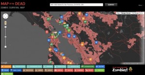
The Map of the Dead, created by digital agency Doejo, applied Google Maps APIs and keyword-based location searches to overlay survival-relevant information onto real-world geography. The interactive tool color-coded population centers in red to indicate high-risk zombie congregation zones, while parks and wilderness areas appeared in dark gray as potentially safer regions.
Supply locations were annotated across the map, highlighting liquor stores, hospitals, gun shops, military bases, cemeteries, and other landmarks relevant to survival planning. The developers were exploring additional location types including schools, pawn shops, and barricades, though keyword search limitations produced false positives for some categories.
The concept drew from the survival logic popularized by shows like The Walking Dead: in any large-scale disaster scenario, knowing where to find food, medical supplies, and defensible positions becomes critical information.
Manhattan: An Island Fortress With Limited Firepower
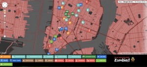
Manhattan’s geography as an island offered a theoretical advantage. Shutting down bridges and tunnels would create a contained environment where survivors could methodically clear threats. However, the map revealed only three gun stores across the entire borough, a significant limitation for a population of over 1.6 million.
The map also flagged a potential hazard: a military installation positioned between two cemeteries turned out to be merely a recruitment center, offering none of the defensive resources its icon might suggest. The takeaway was that Manhattan’s density created both opportunity and risk, with neighborhood-level resources like corner stores not appearing on the macro-level map.
Chicago: Suburbs as Escape Routes and Lakefront Defense
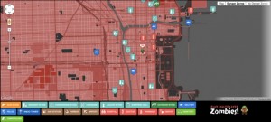
Chicago’s position along Lake Michigan with suburbs stretching in three directions provided multiple evacuation options. For those unable to leave the city, the lakefront offered a defensible position where only three sides required monitoring. Watercraft access also opened the possibility of reaching less populated areas across the lake.
Four military bases within the greater Chicago area represented both a potential asset and a liability. Military installations meant weapons, vehicles, and fortified structures. They also meant that any personnel lost to infection would create an unusually well-equipped threat. The map gave residents the information to weigh those risks based on proximity and access routes.
San Francisco: Peninsula Geography Meets Cultural Challenges
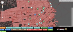
San Francisco’s location at the tip of a peninsula meant that securing just two bridge access points could theoretically isolate the city. The map revealed a notable scarcity of gun stores, reflecting the city’s cultural relationship with firearms.
One geographic advantage was unique to San Francisco: the city had relocated its cemeteries to the nearby suburb of Colma decades earlier, theoretically reducing one category of outbreak risk. The city’s reputation for technological resourcefulness and DIY culture suggested that alternative defensive solutions might emerge from its engineering-minded population.
Emergency Preparedness Through a Pop Culture Lens
While the Map of the Dead was built around zombie apocalypse humor, the underlying concept had practical applications for real emergency preparedness. Knowing the locations of hospitals, military installations, supply stores, and evacuation routes is relevant to any large-scale disaster scenario, from earthquakes to pandemics.
The CDC itself had used zombie preparedness as a public engagement tool, recognizing that the fictional scenario encouraged people to think about real emergency planning fundamentals: supply stockpiling, evacuation routing, and community coordination. The Doejo maps, entertaining as they were, served as a reminder that geographic awareness and resource mapping are foundational elements of disaster readiness.